“It stands majestic, this great tower, looking out across the most sacred piece of our English earth. It looks across the fields where the Romans came with the sword; it looks across the fields where they came again in peace. It looks down on the ways by which came our first Englishmen. It stands in dazzling splendour, enthroned through the centuries, the shrine and cradle of our race” (Arthur Mee, Canterbury).
From the orchards and fields on the gently rising slopes of Stuppington Hill to the south of the city, are some of the finest views of Canterbury Cathedral. A sixteenth century map, The Civitates Orbis Terrarum, published in 1572, provides a bird’s eye view of Canterbury from this aspect. In the foreground, a small group of well-dressed Elizabethans, in fashionable cloaks, long dresses and ruffs, on a grassy hill, appear to be arriving at the city. One of these is possibly Dutch artist, Joris Hoefnagel, or another artist commissioned to map Canterbury, thus revealing the draughtsman’s perspective of the city, that of an outsider, sketched from the east of the River Stour and Wincheap. Christian Jacob reminds us that one of the first questions we should ask of a map is “where am I?”1 but another question might be how did I arrive here? The artist and his companions could have reached the hill from ancient trackways that criss-crossed the area off Wincheap, passing the site where the Kentish martyrs had been executed during the reign of Mary Tudor, or from a path near St Lawrence’s Hospital, which had been dissolved during the Reformation. The map offers only one mode of understanding the space: the detached, bird’s eye view, suppressing the multiplicity of ways humans encounter environments. A perambulation taken of the bounds of the liberty of the city, in the reign of king Henry VII, about the year 1497, reveals there was “a certaine lane in Wincheape on the west part of the said way of Wincheape; which lane leadeth right over the meadows there, as it is known by the markes and bounds, unto the king’s Stowere (Stour)”2 Did the artist visit these water meadows to sketch the trees dotted along the Stour Valley or did he sketch them from the hill?
The legend on the Civitates Orbis Terrarum reads ‘Cantuaria urbs fertilis simae anoliae celebris archiepisco pati sede commendata’ which translates as Canterbury, a fertile city, famous for its cathedral, entrusted as the seat of the archbishop. Fertile in this context may allude to the farmland owned by the Cathedral priory estates to the east of the city, rather than the clay-with-flint soil to the south of the city which was largely unsuited to arable agriculture.3 An orchard in the grounds of St Augustine’s Abbey, reveals the significance of arboreal culture at this time. The William Smith Sloane map published over a decade later in 1588, viewed from the same perspective, only includes one tree at Lady Wootton’s Green and the water meadows near the Stour appear treeless. However, it is known that Leonard Cotton, gentleman of St. Margaret’s, alderman and mayor of the city in 1580, left an orchard and its appurtenances in Winchepe in his will of 1605.4
Maps are not neutral mirrors of reality but symbolic systems that privilege certain forms of knowledge while excluding others.5 The heraldic shields on the Civitates Orbis Terrarum, reveal the power structures at play in the city - monarchy, Archepiscopat, ecclesia cathed. and ‘civitalis’. The spectacle created by the map is one of civic pride, power and privilege and celebrates a sixteenth century sense of progress, order and urbanity. Its publisher, Georg Braun, not only draws our attention to these, but is also creating audience. What the map does not show is commerce or activity - the wine market in Wincheap, the bustling streets just out of view, or the wagons bringing pilgrims to the shrine of Thomas Becket.
An earlier twelfth century map of the waterworks of the Cathedral from the Eadwine psalter, shows orchards, vines and wheat to the northeast of the city as well as a garden near the Campanile mound, illustrating the importance of agriculture to the cathedral community. The map celebrates the cathedral from within its precincts and ignores the city beyond, the representation of the landscape is reduced to that which serves the cathedral - the wheat for the bread, the vines for the wine and the orchards for fruit.
By the seventeenth century, when botanist John Tradescant the Elder gardened for Lord Wotton at St. Augustine’s Abbey, filling his garden with ‘strange and rare plants’, Canterbury was ‘a city of orchards, gardens, fields and green spaces, its houses strung like beads along the narrow streets’6
On a topographical map of Kent published by John Andrews, Andrew Dury and William Herbert in 1769, Stuppington Hill appears as part of a range of rounded hills to the south of the city, extending from Charlton and Milton Downs to Nackington. These are part of the lower dip slope of the North Downs and the hills to the east of Hollow Lane are densely wooded. Although cartographic representations can tell us a lot about place, they can also be reductive and the 1769 map tells us little about the area below Stuppington Hill and how it interacts with the cathedral in its landscape setting. Drafted before the invention of contour lines, the map uses shading to illustrate the 150 feet climb from the city’s edge to the top of Stuppington hill. Only Hon barn linked by a trackway to the fields behind Mrs Rook’s [sic] estate at St Lawrence, and orchards at Merton hint at the land usage of this area.
It is quite likely that the regular pattern in the field behind Mrs Rooke’s house represents a hop field or plantation. In July 1751, the Hon. Mrs Frances Rooke had blocked up the ‘only right and ancient way’ to a small parcel of land called the Poor’s Land which was accessed through her estate and ‘set up hop-poles thereon, merely with an intent to interrupt and impede the Occupiers of the said Poor’s-Land in the use and enjoyment of the accustomed Way’. Angered, the people of the city tore down the hop poles and hop bines causing considerable damage.7 The Andrews map highlights a world of aristocratic privilege. Published according to an act of parliament on 1 January 1769, it records ‘roads, lanes, churches, towns, villages, noblemen and gentlemen’s seats, Roman roads, hills, rivers, woods, cottages and everything remarkable in the county’. The Poor’s-Land is erased from history in a cartographic stroke of the pen. Other hop grounds are also in evidence and in 1796 “a desirable piece of Hop ground, with a messuage and garden, on the whole about one acre; situate in Wincheap, bordering on the high road leading to Ashford and the Weald of Kent” was advertised for sale.8 Hop growing continued into the twentieth century, with Hop pickers advised in 1941 that they could book baskets by writing or calling into Wincheap Farm.9 As the hoppers arrived they would have seen the Cathedral towers rising above the mists pooling in the Stour valley. The rows of hops when viewed from Stuppington Hill would have created a textured canvas of poles, bines and hedgerows, an agricultural palimpsest where Hoefnagel once stood.
By the nineteenth century, the Cathedral’s landscape setting bore the scars of industrialization, with lime works, a ballast pit, a steam saw pit, gasometers and a coal yard now appearing between the Cathedral and Stuppington Hill. With the invention of the railways, the suburb of Wincheap became sandwiched between two lines: the Southeastern and Chatham and the Elham Valley. Thin plumes of steam would have stretched across the valley as trains ripped across the landscape, travelling to and from Canterbury South towards Folkestone. This, and the expansion of the terraced streets in the Martyrs’ Field area, with their coal fires belching out smoke from chimneys, would have created an ever-changing foreground to the Cathedral, with its pale Caen stone towers floating above the haze. The Victorian Traveller’s Guide to Canterbury (1901) advised visitors that ‘time should certainly be found for a walk or drive up one of the neighbouring hills, if only for the sake of the view’, stating, ‘many hold that the stately beauty of the Cathedral can only be realized at a distance’.10
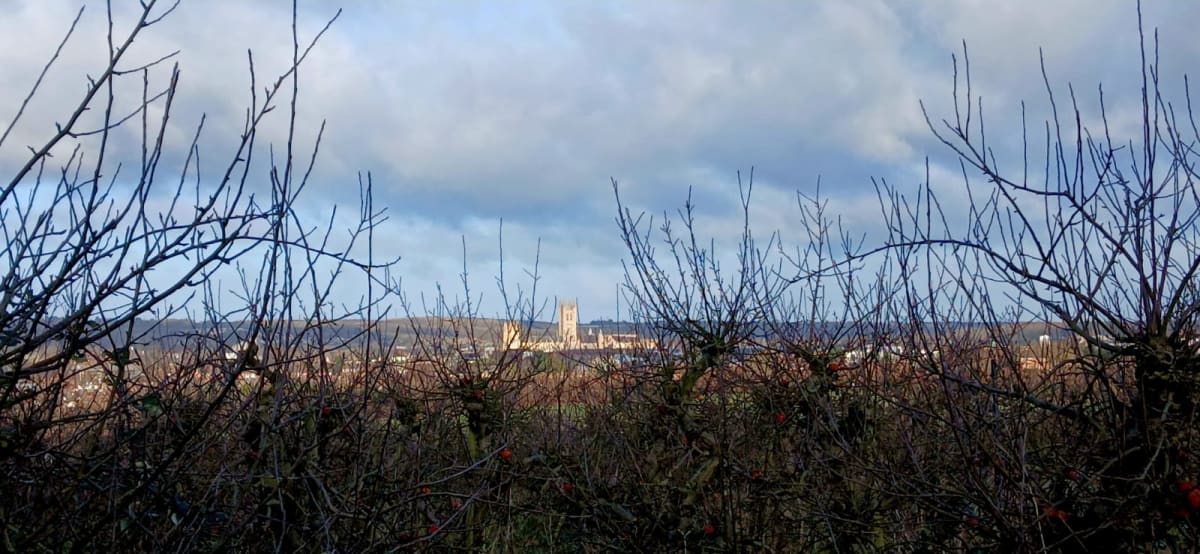
A 1945 ordnance survey map highlights the rural landscape of the city, with symbols of trees, revealing the extent of orchards around the city. Wincheap, Thanington, Cockering, New House, Iffin, Stuppington, Merton and Winter farms are all clearly identifiable as fruit farms to the south of Wincheap. The brown contour lines reveal the height above sea level showing Stuppington Hill between 100 and 250 feet, now covered with orchards. Views of the Cathedral seen through the fruit-laden branches of apple and pear trees, bear witness to a continuity of experience through time and space and cement the cathedral’s relationship with its rural landscape as part of the Garden of England. On clear days, the Caen stone catches the light and looks almost chalky; in overcast weather it becomes a cool grey silhouette. At sunset, the towers glow while the orchards fall into shadow, creating a striking contrast between cultivated land and sacred architecture.
Today some of the orchards around the city have been scrubbed up and the Cathedral hovers above an impoverished landscape. The People’s Trust for Endangered Species has identified that the UK has lost 90% of its traditional orchards since the 1950s.11 Rows of gnarled trunks, spiky branches, and rotting fruit serve as a warning that the Garden of England may soon disappear as the Cathedral and its UNESCO world heritage site becomes choked by its surroundings.
With its Gothic towers reaching for the Heavens, the Cathedral, has dominated the landscape for hundreds of years and ‘maintaining views to and from the Cathedral is crucial to sustain this visual dominance’.12 Hover your mouse over the white circle and click to move the image from left to right to see a futuristic view of Stuppingon Hill if this valued landscape is not protected. This article was published: 14 January 2026.
References
Jacob, C. T. The Sovereign Map – Theoretical Approaches in Cartography Throughout History. The University of Chicago Press, 2006. ↩︎
Hasted, Edward. The History and Topographical Survey of the County of Kent, Canterbury, 1800, British History Online https://www.british-history.ac.uk/survey-kent/. Accessed: 31 December 2025.p.36. ↩︎
Lake J.E., Edward B, Bannister N.I. “Farmsteads and Landscapes in Kent.” Archaeologia Cantiana. 2014;134:105-39, p.113. ↩︎
Hasted, Edward, pp.184-199. ↩︎
Harley, J.B. and Woodward, D. (eds.) The History of Cartography: Cartography in Prehistoric, Ancient and Mediaeval Europe and the Mediterranean. Vol. 1. University of Chicago Press, 1987, p.506. ↩︎
Potter, Jennifer. Strange Blooms : The Curious Lives and Adventures of the John Tradescants, 2006, pp.82,84. ↩︎
‘Letter’, Kentish Weekly Post or Canterbury Journal, 14 August 1751, no.3523, p.1. ↩︎
‘Freehold Estates’ Kentish Weekly Post or Canterbury Journal, 22 April 1796 no 1695, p.1. ↩︎
‘Hop pickers’ Kent Herald 18 June 1941. ↩︎
Shetlock, John. The Victorian Traveller’s Guide to Canterbury, 1901, p.99. ↩︎
Canterbury Cathedral, St Augustine’s Abbey, and St Martin’s Church ↩︎